Notably dry and slightly cooler than average - a quiet month but which finished cold and wintry
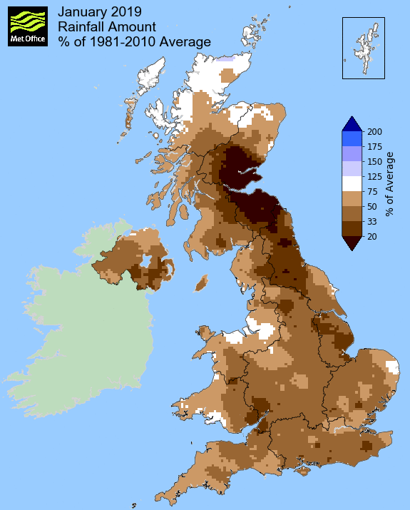
In an otherwise uneventful month, January was notably much drier than average. Indeed the first half of the month was very dry with just 2.7 mm of rain and it was only a few 'heavier' falls in the final week that prevented it from finishing exceptionally dry.
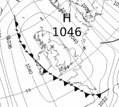
High pressure was dominant during the first half of the month, remaining above 1030 MB up to the 11th and was at its highest, 1046.6 Mb, on the 2nd, this being the highest yet recorded at this site. Pressure fell and remained low from the 26th in which time we had three relatively wet days, but despite the low pressure the pressure gradient then slackened and with an airflow of Arctic origins, winter finally and belatedly, commenced.
However, despite the dryness of the month it was often dull, the high pressure trapping in an anti-cyclonic gloom, but then the high pressure ensured that it was a calm month and with a mean wind speed of just 5.42 Mph this was the calmest January in my records.
The frosts at the month's end were keen and with low day-time temperatures the little bit of snow that fell early on the 29th was still laying on the ground in February!
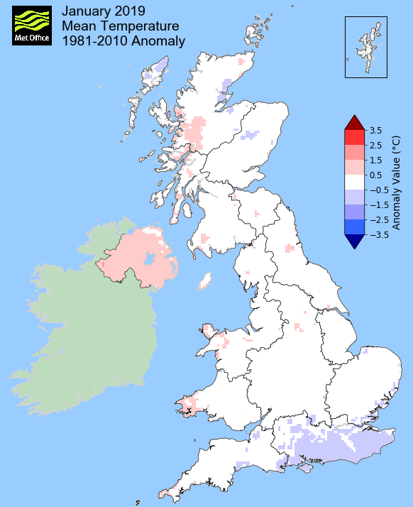
MSLP of 1017.6 Mb was +5.5 Mb above the local average for the month and overall a mean minimum of 0.03°c and a mean maximum of 5.65°c saw the temperature 0.4°c below the ten year average for this site.
It was the coldest since 2011 and of the eleven now recorded, two have been colder and eight warmer. The highest maximum temperature recorded was 11.0°c (7th), the lowest minimum -8.1°c (31st).
Rainfall of 39.3 mm (Crosby Ravensworth School 43.9 mm) was 26.3% of average for 2008-18 and made it the driest January since 2010.
Of the twelve now recorded, ten have been drier and just the one has been wetter.
During the month, the following was recorded: snow fell on five days (22nd, 23rd and 28-30th), was laying on the ground (to a depth of least 1 cm at 0900 GMT) on three days and fog (at 0900GMT) was recorded on two days (23rd and 29th).
At the Met' Office site at Newton Rigg, rainfall of 40.4 mm (39.8%) was also the driest since 2010 and in a series back to 1900 January has been drier in 16 years and wetter in 103.
A mean temperature of 3.15°c is the coldest since 2013, is 0.15°c below the average for 1981-2010 and in a series back to 1952, January has been warmer on 34 occasions and colder in 33 years.
Locally, rainfall percentages were well below average, typically in the range of 45-50% of normal. Seathwaite was one of the few sites that managed to nudge just above 50% - at Orton it was the second driest (to 1997) in a record that commenced in 1967.
Figures from the Environment Agency�s rainfall sites were, (figure in brackets being the monthly average for 1961-90) �Data kindly provided by the Hydrometry and Telemetry team of the Environment Agency (Penrith)�:
Kirkby Thore 31.0 mm (70.1 mm)
Haresceugh Castle (Kirkoswald) 45.7 mm (91.7 mm)
Brothers Water 133.8 mm (277 mm) and
Orton (Shallowford) 51.2 mm (186.8 mm [average for 1967-2017])
203.6 mm at Seathwaite Farm (Borrowdale - 372 mm [average for 1981-2010]).
General Synoptic Report for the Month
The month began with high pressure (HP) becoming dominant over the UK and very much in control. This saw the highest recorded pressure (1046.6 MB on the 2nd) at this site since its records commenced in 2009.
The high pressure would remain over the UK up to the 6th, but this trapped in an anti-cyclonic gloom resulting in the days being cool, calm and cloudy, occasionally hazy - but it did remain dry.
Day-time temperatures slowly recovered from 2.7°c (2nd) to just over 5°c with the final day in the period becoming increasingly warmer, continuing overnight into the 7th which at 11.0°c (51.8°f) would be the month's warmest day.
The HP had been very slowly moving SW through the UK and by the 7th it had slipped into Biscay which allowed a low pressure (LP) system NW of Scotland to exert its influence. This saw a cold front travel south over the UK during the day, bringing with it windy conditions and a little light rain.
However, the general theme of dry but cloudy that had typified the start to the year would continue - in the first half of the month only 2.7 mm of rain was recorded. This was all courtesy of pressure remaining high and if not over the UK, at least nearby.
Come the 8th the HP had re-positioned itself in the Atlantic to the west of Eire and whilst the 8th would enjoy a day of sun, thereafter it reverted to type.
With the HP re-established to our west it again fell calm and both the 9-10th saw air frosts, but a warm front associated to LP north of Iceland, laying north-south through Eire, was gradually nudging towards the UK. This saw a foggy start to the 10th, lasting most of the morning and only marginally lifting during the day - the next few days would remain dry, but overcast.
The HP was squeezed south during the 11-12th by LP over Iceland and this brought a brisk W'ly over the top of the HP and whilst still dry, it did become mild. The temperature rose to 10.3°c on the 12th and most days and nights saw temperatures above average.
The constant battle between HP at least being close to and trying to exert its authority over the UK, but being squeezed south by LP travelling over its northern edge, remained the default position up to the 16th.
During the 16th a LP system tracked to the north of the UK and behind this LP a cold front quickly followed, moving north-south across the UK. However, the associated rainfall was only light, but once again HP would start to ridge in just to the west of the UK.
With HP to the west and LP to the east, a cold N'ly wind was drawn down and the temperature quickly dropped. The next few days (17-19th), with the HP being the more dominant feature, were cold with air frosts, dropping to -4.2°c on the 18th. The 17th had enjoyed plenty of sun, but once again as fronts associated to LP in the Atlantic started to encroach, the murk returned.
By the 19th a LP system was sat over the UK and the murk was now accompanied by spells of light rain and/or drizzle. Needless to say the HP wasn't far away and a brief ridge overnight into the 21st was enough to clear the skies and allow the temperature to drop to -4.5°c.
However, in this on-going battle, LP was fast approaching and the murk descended ahead of a cold front that would give us our first real rain of the year. A wet afternoon and evening followed giving 7.3 mm of rain.
However, on the 22nd we awoke to a slight dusting of snow on the ground - the first snow of winter!
Behind the cold front it had turned wintry and there were further snow showers during the day. However, there was also some brighter moments and this saw Shap record 2.9 Hrs of sunshine - we were in a slightly colder phase.
Throughout January the threat of cold conditions had been ever present, all due to a 'Sudden Stratospheric Warming' (SSW) that had occurred back in December, but it really never came to pass. Certainly the cold NE'ly that had been suggested never materialised and the forecasting of the cold spell that had been expected became somewhat challenging.
It remained cold through to the 24th with a few more frosts and another dusting snow on the 24th - there was also a morning of fog on the 23rd before it brightened up in the afternoon.
We then briefly had a return of the Azores High ridging north before being squeezed out by LP. The 26th saw LP in the Atlantic deepening to 981 MB and moving quickly across the UK which brought 11.7 mm of rain and ensured a miserable and the month's wettest day.
But once again the battle ensued! As the LP exited out into the North Sea, HP started to ridge in the Atlantic and again drew down a very brisk, cold and raw NW'ly wind - the 27th may have seen sunshine and a maximum temperature that was respectable (4.8°c), but it felt bitter and the wind was cutting.
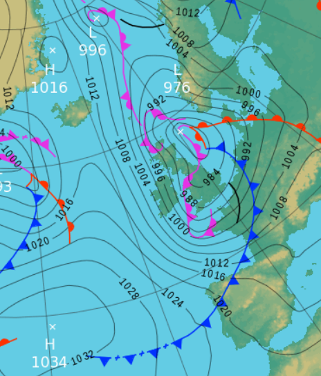 1200 Hrs 27th - High pressure west, low pressure to the east = a cold and brisk NW'ly
and so began a cold and wintry end to the month; the first taste of something resembling winter that we have had thus far since the season began.
With the LP from the 27th continuing east the pressure gradient slackened overnight into the 28th and this saw the skies clear with a sharp frost of -4.5°c to start the day - and what a lovely day it was with wall to wall sun. However, entering stage left was a frontal system that arrived late in the evening and which would bring us our first meaningful snowfall.
Initially a warm front brought sleet on its leading edge, turning to rain overnight into the 29th. Then with the passage of the cold front behind that sleet turned to snow from just before 0800 Hrs, falling steadily through to 1330 hrs and subsequently it was another bitter cold day (1.1°c).
With a generally slack pressure gradient and airflow originating from the Arctic it remained cold and apart from a further thin cover of snow overnight into the 30th, we had no more snow. However, what had fallen on the 29th stayed with us and was still laying on the ground into February.
The issue then became one of icy surfaces and just how low would the temperature fall? Having a snow cover certainly aided the drop in temperatures.
Overnight into the 30th there was too much cloud for the temperature to fall too far and indeed it was only when the clouds cleared after 0700 hrs that the temperature began to tumble, down to -5.1°c.
The 30th was a fine and sunny day (Shap had 7.3 Hrs of sunshine), pockets of cloud did come and go and like the 31st to follow, would see the temperature slowly climb, but which would still be below freezing come midday. However, even in January a little bit of sun can make a small difference and the temperature on both days rose to just either side of 2.0°c before quickly falling again.
Although the 31st with a minimum temperature of -8.1°c (17.4°f) and still languishing at -6.6°c at 09GMT, had a long way to recover just to get to freezing point!
Rainfall totalled 39.3 mm for the month, with rain recorded on 17 days of which 6 were 'Wet days' (1.0mm +).
The Mean Temperature for the month was 2.84°c -- The Mean Max' was 5.65°c -- The Mean Min' 0.03°c.
We had 14 Air Frosts in the month (year 14) -- Grass frosts totalled 20 (year 20).
The 1 foot soil temp ranged from a low of 3.0°c on the 31st to a high of 7.0°c on the 1st -- with a monthly mean of 5.0°c
The 1 meter soil temp ranged from a low of 6.0°c on the 31st to a high of 7.6°c on the 1st-2nd -- with a monthly mean of 6.9°c
JANUARY 2010
FEBRUARY 2010
MARCH 2010
APRIL 2010
MAY 2010
JUNE 2010
JULY 2010
AUGUST 2010
SEPTEMBER 2010
OCTOBER 2010
NOVEMBER 2010
DECEMBER 2010
JANUARY 2011
FEBRUARY 2011
MARCH 2011
APRIL 2011
MAY 2011
JUNE 2011
JULY 2011
AUGUST 2011
SEPTEMBER 2011
OCTOBER 2011
NOVEMBER 2011
DECEMBER 2011
JANUARY 2012
FEBRUARY 2012
MARCH 2012
APRIL 2012
MAY 2012
JUNE 2012
JULY 2012
AUGUST 2012
SEPTEMBER 2012
OCTOBER 2012
NOVEMBER 2012
DECEMBER 2012
SUMMER 2012
REVIEW OF 2012
JANUARY 2013
FEBRUARY 2013
MARCH 2013
APRIL 2013
MAY 2013
JUNE 2013
JULY 2013
AUGUST 2013
SEPTEMBER 2013
OCTOBER 2013
NOVEMBER 2013
DECEMBER 2013
REVIEW OF 2013
JANUARY 2014
FEBRUARY 2014
MARCH 2014
APRIL 2014
MAY 2014
JUNE 2014
JULY 2014
AUGUST 2014
SEPTEMBER 2014
OCTOBER 2014
NOVEMBER 2014
DECEMBER 2014
WINTER 2014
REVIEW OF 2014
JANUARY 2015
FEBRUARY 2015
MARCH 2015
APRIL 2015
MAY 2015
JUNE 2015
JULY 2015
AUGUST 2015
SEPTEMBER 2015
OCTOBER 2015
NOVEMBER 2015
DECEMBER 2015
REVIEW OF 2015
JANUARY 2016
FEBRUARY 2016
MARCH 2016
APRIL 2016
MAY 2016
JUNE 2016
JULY 2016
AUGUST 2016
SEPTEMBER 2016
OCTOBER 2016
NOVEMBER 2016
DECEMBER 2016
REVIEW OF 2016
JANUARY 2017
FEBRUARY 2017
MARCH 2017
APRIL 2017
MAY 2017
JUNE 2017
JULY 2017
AUGUST 2017
SEPTEMBER 2017
OCTOBER 2017
NOVEMBER 2017
DECEMBER 2017
REVIEW OF 2017
JANUARY 2018
FEBRUARY 2018
MARCH 2018
APRIL 2018
MAY 2018
JUNE 2018
JULY 2018
AUGUST 2018
SEPTEMBER 2018
OCTOBER 2018
NOVEMBER 2018
DECEMBER 2018
REVIEW OF 2018
OTHER ARTICLES
The Oldest Inhabitant
An Inch Of Scotch Mist
But it's meant to be Summer (Summer 2017)
© Darren Rogers 2010-18
Want to comment on this site? email